Across many parts of Europe and other temperate regions, floods are becoming more sudden and destructive. Small streams that once flowed gently through towns are now transforming into dangerous torrents within hours. Scientists warn that the rising flood threat is not simply caused by “more rainfall.” Instead, the pattern and intensity of rainfall itself are changing, creating new risks that communities are still struggling to understand.
Recent climate studies reveal that storms are becoming shorter but more intense, unleashing heavy rain over brief periods. This invisible shift is quietly reshaping flood hazards and challenging traditional flood protection systems designed for slower, steady rainfall.
Rainfall Is Changing — And That Matters More Than Total Rainfall
For decades, climate researchers predicted that global warming would increase rainfall in many regions. However, new research suggests that how rain falls may be even more important than how much falls overall.
Scientists analysing more than 100 years of weather data in Austria discovered a striking trend. Short, high-intensity storms lasting only a few hours have increased by roughly 15 percent in some regions over the past four decades. In contrast, long-duration rainfall events lasting several days have shown far smaller changes.
This shift has been observed in multiple Alpine and Central European areas, suggesting that global warming is influencing rainfall behaviour at large atmospheric scales rather than only affecting local weather patterns.
Why Warmer Air Creates More Violent Storms
The scientific explanation behind this rainfall transformation is linked to basic atmospheric physics. Warmer air can hold more moisture. As global temperatures rise, the atmosphere absorbs additional water vapor, providing storms with more fuel.
Warm air is also more buoyant, meaning it rises more quickly. This rapid upward movement triggers stronger storm cloud formation through a process called convection. Convective storms often produce thunderstorms and sudden cloudbursts that release enormous amounts of rain within short periods.
Instead of experiencing steady rainfall throughout a day, communities may now face extremely heavy downpours delivering large volumes of water in less than an hour. Urban drainage systems and river channels designed for gradual water accumulation often cannot cope with such sudden surges.
Why Short Storms Create Higher Flood Risks
Many flood prevention systems are built to handle rising water levels over several hours or days. Sudden rainfall bursts overwhelm these systems because water enters drainage networks and river basins almost simultaneously.
Even if total rainfall remains unchanged, the concentration of rainfall into short periods significantly increases flood danger. A storm delivering 40 millimeters of rain over six hours may cause manageable flooding. The same rainfall falling within 45 minutes can lead to severe flash floods.
Communities are often prepared for heavy rain but not for intense rainfall occurring all at once.
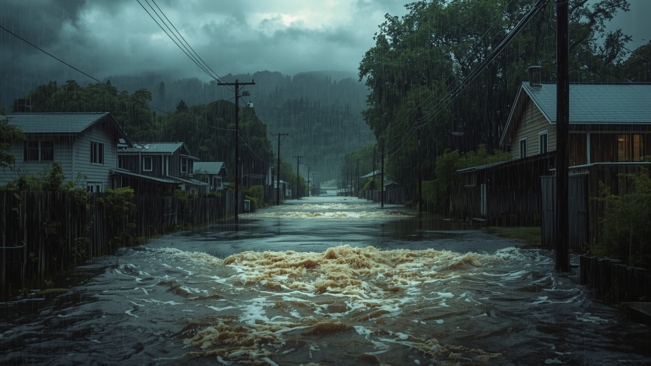
Small Streams Are Becoming the Biggest Threat
One of the most concerning findings from recent research is how small watercourses react to changing rainfall patterns. Minor streams and creeks respond extremely quickly to intense rainfall events. Water levels can rise dramatically within minutes, leaving little time for warnings or evacuations.
Larger rivers such as major European waterways respond more slowly because they collect water from wide regions. These rivers are still vulnerable to long periods of rainfall but are less sensitive to brief storm bursts.
This difference means climate change can increase flood risk in smaller valleys, mountain communities, and suburban areas even if large river flooding remains relatively stable.
Bridges, drainage pipes, and culverts designed for traditional rainfall patterns often become blockages during flash floods, forcing water to overflow into surrounding neighborhoods.
Regional Differences in Rainfall Patterns
Climate change does not affect all regions in the same way. Mediterranean countries such as Spain, Italy, and Greece often experience longer dry periods due to warming temperatures. However, these dry conditions can sometimes lead to sudden and severe storm events when moisture eventually accumulates.
In Alpine and Central European regions, rainfall intensity is increasing more consistently. These areas face rising risks of flash flooding, particularly in mountainous terrain where water flows quickly downhill.
Northern and eastern parts of France and similar European climates may experience rainfall changes similar to Central Europe, while southern Mediterranean areas may face fewer but more extreme storm events combined with drought conditions.
Cities Face Growing Flood Challenges
Urban environments are particularly vulnerable to short, intense rainfall. Cities contain large areas of concrete, asphalt, and rooftops that prevent water from soaking into the ground. Instead, rainfall quickly flows into storm drains and sewer systems.
Many drainage networks were built using rainfall models that assumed storms would be less intense. As rainfall bursts grow stronger, these systems become overwhelmed, leading to street flooding and water entering homes and underground infrastructure.
City planners are increasingly exploring new flood adaptation strategies. These include expanding drainage systems, creating green spaces that absorb rainfall, and designing areas such as parking lots and parks that can temporarily hold excess water during storms.
Understanding Flash Floods and Pluvial Flooding
Two terms frequently appear in modern flood warnings. A flash flood refers to a sudden rise in water levels in rivers or streams following heavy rainfall. These floods often occur rapidly and without warning.
Pluvial flooding occurs when rainfall accumulates faster than drainage systems can handle, causing water to pool on streets, basements, and low-lying urban areas. Pluvial floods can happen even when rivers remain within their banks.
Both types of flooding are becoming more common due to increased rainfall intensity.
How Scientists Are Predicting Future Flood Risks
Hydrologists and climate scientists are developing advanced flood prediction models to understand how rainfall changes will influence water flow in different landscapes. These models examine how small increases in rainfall intensity affect local flood risks.
Early simulations suggest that even a 20 percent increase in peak rainfall intensity can significantly increase flood damage. Infrastructure designed using older rainfall assumptions may no longer provide sufficient protection.
Insurance companies and urban planners are beginning to use detailed flood mapping systems that analyze small streams and drainage networks rather than focusing solely on large rivers.
Practical Steps Communities and Homeowners Can Take
While large-scale flood management requires government planning, individual communities and homeowners can reduce risks by maintaining drainage systems, clearing blocked gutters, and understanding local evacuation routes.
Simple awareness of flood warning levels and nearby safe locations can significantly improve emergency response during sudden storms. As rainfall patterns continue changing, preparation and rapid response will become increasingly important.
Conclusion
The growing flood threat in many regions is not simply a result of increased rainfall but a transformation in how rainfall occurs. Short, intense storms fueled by rising global temperatures are creating new flood risks that traditional infrastructure may not handle effectively.
Small streams, urban drainage systems, and mountainous regions are particularly vulnerable to these changes. As climate patterns continue evolving, adapting flood protection strategies and improving public awareness will be essential for reducing damage and protecting communities.
Understanding this invisible shift in rainfall is the first step toward preparing for a future where storms may arrive faster, stronger, and with far greater impact than before.